History
Westwood Hills resides atop a ridge on the western edge of Napa, California. Despite being a center of intensive viticulture in California the slopes here were used for cattle grazing.
As the city of Napa grew developers eyed the area for development and plans were submitted to build 350 homes on 110 acres here in the 1970's. Community opposition halted the plans and efforts were launched to raise enough money to purchase the property, which occurred in 1975. Countless volunteer hours were then logged to blaze trails and create improvements to the property to make it functional as a proper park for the city.
The Trails
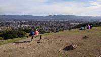
Families enjoying the view from the top of the park overlooking Napa Valley below. This popular spot is the focal point for most visitors to the park.
For a somewhat small city park, Westwood Hills can attract a large number of people. The main parking area has room for perhaps a dozen cars. Thankfully, there is ample parking along Browns Valley Road, but be careful crossing the street if you must park on opposite side of the road.
Eucalyptus trees dominate the area near the main trailhead. As they usually do, these large trees shed their ample strips of bark onto the trail surface below. The trees are not as common elsewhere in the park. To give you an idea of how fast these trees can grow, what one sees here is actually regrowth from the 1970's. When the park was first established a number of the Eucalyptus was cut down following a fire that swept through the area. The dedication to keeping the Eucs at bay appears to have dwindled. Interestingly, there appears to have been a new burn through the grove in 2017 and not one connected with the larger North Bay fires of that year.
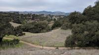
A view from the main trail overlooking side trails cutting in various directions. Houses in the distance mark the park boundary.
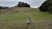
The terrain is surprisingly rough for a city park not far from downtown. Valley View Trail, the main trail from the trailhead to the park summit, is a wide, rocky packed dirt trail that's a solid difficulty level of 3. Some of the side trails take things up a notch in terms of steepness and might be better classified as a knee challenging 4. None of those steep segments are too terribly long.
As you might expect, the park summit is the main goal for almost every visitor to the park. This means the lion's share of the traffic is along that main path that provides the easiest and shortest way to the top. There's a large open area and benches at the peak that also provides some incentive for people to stop and soak up the views. Don't be surprised if you find a crowd.
The park boundary cuts right across the peak as a house shares the high point with the hikers. In a fenced in area a thick cluster of radio antennas are partially camouflaged by fake tree branches. The branches are randomly attached to the towers that from a distance do a fair job of disguising the installation.
Much of the park is fairly well covered by ample tree shade, but there are spots, such as this one, along the park's perimeter where the sky opens up a bit.
The house at the summit has a history of its own. A developer snatched up the parcel at auction and rammed through construction of a sprawling three story mansion to the consternation of many Napans. Irregularities with permitting and inspections held up progress for some time. The house and communications tower does not block views over Napa Valley, but it reportedly does block what used to be views of San Francisco and the Golden Gate Bridge. A sad loss.
The density of people falls off drastically on the side trails, though they are hardly devoid of people. A trail roughly follows the perimeter of the park and crisscrossing connector segments provide more than one way to traverse the terrain to get from one place to another. Most trail intersections do not contain signage and even when there is a marker of some kind it's generally not the kind that truly helps to pinpoint one's location and navigate to a desired endpoint.
According to signs observed at the park entrances, a Mountain Lion has been spotted within in the park. A more common sight might be the cows that are allowed to graze on the property at certain times of the year.
If you have any questions about the plants and animals the might be found here, there's no better place to get answers than the Carolyn Parr Nature Museum which resides adjacent to the park's main parking area. This small museum is run by volunteers from the Napa Valley Naturalists.