Old Hancock Trail

Trail
3.50 Miles
330 Feet
N/A
2stars (2.40)7
1star (1.29)
2point5stars (2.64)
No
Yes
No
No
Canyon Lake
Comal
More Info

Getting there: From IH-35 north of New Braunfels take exit 191 and head west on FM 306. Go beyond Canyon Park Road and past the intersection with 3424. Turn onto Hancock Road on the left. Proceed for almost 2 miles to the trailhead parking area.

The Hike: Old Hancock Trail is a relatively new trail first opened up in 2000. It follows the north shore of Canyon Lake in Comal County and provides about 7 miles of hiking out and back. It appears the trail's primary purpose is to provide a place for horseback riding, but like many such trails hiking is allowed. During the hike the solitary horseback rider I saw was the only person I saw on the trail. Most likely you'll see folks in their boats along the shore.

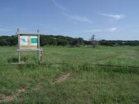
The trailhead sign resides at the eastern edge of the parking area.
The trail begins at the waypoint marked "Trailhead", which lies at the end of Hancock Road. There is a large unpaved parking area and the actual trailhead is at the eastern end of the lot. There was a Port-O-Potty near the trailhead for those who need to use the facilities.

Right away the trail gives one a taste of what's to come. Most of the hike will be over open meadow with little cover. Whatever you bring, be sure to bring sunscreen. You'll need it. The trail surface throughout is packed dirt and mowed grass, with a bit of rock thrown in here and there. Since it generally follows the shore of Canyon Lake there is relatively little elevation gain for a hike of this length.

A typical trail view. Open spaces, wildflowers and houses on the ridge above.
Those looking for high-point vistas won't find them here. But views of the hills surrounding the lake are ever present and something unexpected, lots of animals. With little cover and plenty of nearby homes I was quite surprised to encounter no less than 13 deer throughout the hike. The small clumps of brush, high grasses and wildflower fields hide an enormous number of them. I spotted more deer on this hike than any other.

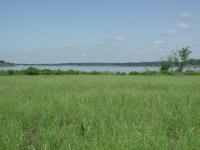
Canyon Lake from the trail. Note the line of brush along the shore that mostly keeps the trail away from the water.
How about another superlative? Wildflowers. The terrain at Old Hancock appears ideal for wildflowers. During a May visit the place was covered with Mexican Hats, more than I've seen on any other hike. Standing 3 feet tall and bunched together in fields extending a couple hundred feet in all directions, they were a sight to behold. So thick and tall were the wildflowers that one deer was seeking shelter in the flowers alone. Had she not darted off when I was near I never would have known she was there.

The trail proceeds mostly to the east, but the shoreline is circuitous so you're likely to head in all directions to get to the end. There are a couple of side trails that one can take. However some of the side trails indicated on the official map do not appear to be in usable shape. If you keep to the most obvious trail and follow the markers along the way you should have no problems getting from point A to point B.

With all of the wildflowers around butterflies are sure to appear. This one works on some Thistle.
Despite skirting the lake shore the hike actually provides but a few great views of the lake up close. The trail sits at almost the same elevation as the water itself and the shoreline is often shrouded in a thicket of brush, the kind the deer like. One of the better spots for seeing the lake is at the waypoint marked "Lake". Here a cove reaches to a spot where the trail passes along what appears to have been a steep rock wall, the top of which now sits a mere couple of feet above the water. It's a nice place to sit for a rest and judging from the rope hanging from a tree, a good place to take a dip.

The trail comes to an end at the edge of the road leading to Canyon Park on the peninsula. The trail makes a flattened loop here and then doubles back to the trailhead. It's a shame that the trail doesn't continue down to Canyon Park itself, but this hike, along what at first glance appeared to be a monotonous terrain turned out to have a few pleasant surprises.

Photos
View Of The Trail
This is a view of the trail. (Photo by Blaze)
Trailhead
This is one place where the trail starts/ends. (Photo by Blaze)
Parking Area
This is a view of the parking area near the trailhead. (Photo by Blaze)
Deer
One of the many deer encountered along the trail. This one makes a quick getaway across an open field. (Photo by Austin Explorer)
Longhorn
Vacation homes are not the only thing to be found along the lake. Ranching still makes its presense. (Photo by Austin Explorer)
Lake Access
One of the few spots along the trail that get right up on the water. (Photo by Austin Explorer)
Log Entries
CLOSED
By texaskdog on 6/25/2015
Rating: halfstar Difficulty: halfstar Solitude: halfstar
Distance: N/A Duration: N/A

We drove all the way out from Austin. The parking lot is gated off and I can see the sign that is posted on this site but there is nothing in it anymore.  I think the trail is under water.  We did the Madrones trail instead.

Old Hancock Trail
By Blaze on 3/28/2015
Rating: 1star Difficulty: 1star Solitude: 1point5stars
Distance: 6.10 Miles Duration: 2 hours, 8 minutes

I hiked the Old Hancock (Equestrian) Trail with my girlfriend.  The hike takes you around part of Canyon Lake, but it's not very scenic.  Just a trail that allows you to get some miles in.

Good walk
By RMA on 2/9/2008
Rating: 3stars Difficulty: 2stars Solitude: 3stars
Distance: 7.00 Miles Duration: N/A

It s not easy finding Handcock Rd. off of FM 306 because its marked with a small sign on a 55 mph road.  When coming from IH35 on FM 306 its 1.9 miles past the flashing lights of the 3424 & FM 306 intersection.  If your coming from the other direction go to the 3424 & FM 306 intersection turn around and follow the same directions.  

Great Hike
By satterthwait on 5/1/2005
Rating: 4stars Difficulty: 2stars Solitude: 5stars
Distance: 4.00 Miles Duration: N/A
Easy Hike, but wonderful--only went in about 2 miles and back out. Would not want to hike in summer--no shade and if you go--take sunscreen! Others mentioned trail was wet last year--totally dry now. No one around except a couple people on horses. Saw 4 deer and many birds! If you don't mind the sun and want an easy hike with solitude--this is the one!
too wet
By theatrewizard on 6/13/2004
Rating: N/A Difficulty: halfstar Solitude: 3stars
Distance: 0.75 Mile Duration: N/A
after the heavy rains, the trail in not visible at all.... due to the fact that it is completely under water.... We will try again in a few weeks.
Lots of Sun
By Austin Explorer on 5/15/2004
Rating: 3point5stars Difficulty: 2stars Solitude: 3stars
Distance: 6.34 Miles Duration: N/A
Don't expect much shade here. Totaled almost 6.5 miles, some side trails could add more to that. Saw/heard at least 13 deer on the trail! Terrain is generally flat with the trail overgrown in some areas. Just follow the mowed path. Encountered only 1 other person on the trail, and he was on horseback.
By kelgrad99 on 8/24/2003
Rating: N/A Difficulty: 1star Solitude: 2point5stars
Distance: 7.00 Miles Duration: N/A
The hike was 7 miles roundtrip. I hiked it on a Sunday morning, and never saw another person on the trail (which was nice) -- only some fisherman offshore. There are some birdwatching opportunities if you bring your field glasses. Shady spots are few and far between, so bring your sunscreen. My main complaint is that there were several areas where the trail is not well-defined, and there are no markers to point hikers in the right direction. (Most of the markers that ARE present appear in areas where I thought the trail was obvious.) With some additional directional markers and distance markers (I saw only one the entire hike, at the 1 mile mark), this would be a decent trail.
Recommended Item
Recommended Item Hiking Texas: A Guide to the State's Greatest Hiking Adventures (State Hiking Guides Series)
Laurence Parent
List Price: $24.95 Your price: $21.10 Buy Now
From the rugged Guadalupe Mountains in the west and the deep canyons of the Red River in the Panhandle to the lakes on the eastern landscape, the Texas backcountry is as spacious and diverse as the Lone Star State itself. This guide contains unforgettable hikes that suit all abilities and interests.