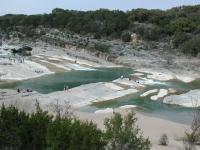
Looking down on Pedernales Falls. The true extent of the falls cannot be captured in one picture.
From Austin head west on Highway 290. After near 30 miles turn north on RM 3232. Continue north until 3232 dead ends into a T-section in the road. The entrance to Pedernales Falls State Park is to the right off of FM 2766. The road into the park passes the ranger station about half way through the park. After paying the entrance fee continue on the main road to the north to the circle that marks the end of the road and trailhead parking area.
The Hike: The Falls Trail in Pedernales Falls State Park is by far the most crowded in the park. The short trail leads to the waterfall that gives the park its name. Being one of the largest falls in central Texas, this natural wonder draws a large number of visitors.
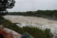
A view of the Pedernales River flooding. This area of the country experiences catastrophic flooding and the river is extremely dangerous at these levels. Note the difference between this shot and the wide angle shot earlier. (Photo by
geoiii)
The trail begins at the waypoint "Trailhead". Here there is parking, restrooms and a soda vending machine. On particularly nice days this parking area will fill up and people start parking along the road further to the south.
The path I took followed branches of the trail that veered off to the right. Most people take the more direct path to the left. In making this choice the first half of the walk is a bit less crowded, though by no means tranquil. When the trail gets near the Pedernales River at the waypoint "Overlook" the reason for this path becomes obvious. A bluff overlooks the falls upstream and provides a something like a bird's eye view.
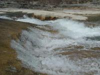
Though the falls descend over sloping rock layers the rapid descent of water is enough to produce the roar of falling water.
After leaving the overlook head to the north and soon the path will intersect with the main trail as it prepares to descend into the Pedernales River floodplain. Immediately before the descent there is another overlook. Stairs made of stone descend to the river bottom.
The falls are made up of a couple of different sections. Upstream the waters flows over slanted rock. Though the water flow is impressive and the falls create a great deal of noise, it is not a waterfall with a great deal of perfectly vertical drop. The scene is reminiscent of a table that's been tilted with its contents tumbling toward an edge.
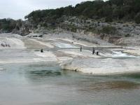
Looking upstream to the sloping rock portion of the Pedernales Falls. Here the slant of the rock layers to the right show the geologic feature that forms the falls.
Downstream the falls snake through small, twisting slots cut through the rock. At times the slots, some with walls over 6 feet tall, join and diverge like a maze. Depending upon the amount of rainfall that the area has experienced lately the amount of water in the maze varies in spots from rushing water, stagnant pools or bone dry rock.
The far side of the river is private property, but feel free to follow the river's path both upstream and downstream to explore some more of falls. Note that for safety reasons swimming in the river at this point is not allowed. For a nice swim to cool off refer to the official park map and pick a swimming spot farther downstream.
The trip back to the parking area returns up the stone steps and then follows the main trail back to the southwest instead of heading south for the path that I used on the way out. The length of this hike can vary widely, depending upon how much exploring you do along the falls themselves. On this particular day I recorded three quarters of a mile.