History
Mount Burdell, both the north and south face of the 1,558 foot high peak, was part of the original land grant held by Camillo Ynitia, a native American ally of General Vallejo. Cattle grazing took place on these slopes and even rock quarrying. Some of the rock extracted here was used as cobblestones for early San Francisco streets.
The 1,600+ preserve was purchased by the Marin County Open Space District in 1977 after having suffered years of overgrazing. Cattle grazing continues to be practices today but under tighter constraints.
The Trails
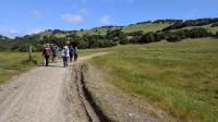
Lots of Sun to be found on the open grasslands.
The Mount Burdell Open Space Preserve shares the same mountain with
Olompali State Historic Park. Though Olompali has a number of amenities, particularly historical in nature, that Mount Burdell can't match, there are some good reasons to head on this side of the mountain for your next hiking outing.
Mount Burdell OSP is on the quiet side of Mount Burdell. Olompali's slopes face the very busy Highway 101 and read noise is more prevalent than on the south side here. As you get towards the edges of the preserve car noise may be more noticeable but within the core of the park it's relatively quiet.
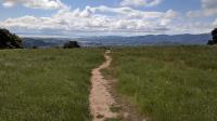
Looking towards Novato and San Pablo Bay.
Parking at a Marin preserve without a parking lot is normally a pain. Street parking can sometimes be sparse and generate some hostile looks from neighbors. But the parking along San Andres Drive is excellent with a good quarter mile or more of the road running along the park boundary, which means not having to park in front of people's homes. Even during a visit on a day that locals pronounced very busy there was still some parking left.
The terrain here is hilly with dirt and rock lined trails. The majority of the mileage in the park is composed of wide multi-use fire roads. There's a mixture of open grassland with pockets of trees with Oaks and Bay dominating. Unlike the north slope of Mount Burdell, the tree cover here is far more sparse and care should be taken for protection from the Sun.
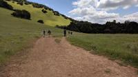
Hikers looking for tougher outings can ascend to the top of Mount Burdell to the left.
Though hilly, it's possible here to tailor the level of effort one has to exert by choosing one's route carefully. Constructing a loop using the fire roads around Hidden Lake yields elevation gains of only around 600 feet and somewhere around 4-5 miles. Tacking on some of the trails that ascend higher up the mountain towards the preserve's boundary with Olompali will almost double the elevation gain in addition to the extra mileage required. Check out Marin County Parks' excellent trail map to plan your outing.
Trail markers at most intersections make navigating the park easy, particularly when combined with their excellent park map. There are no maps at the trailhead however, so be sure to print up what you'll need prior to your visit.
At the intersection of the San Carlos Fire Road and Michako Trail look for the distinctive tree with a complexion issue. This granary tree is studded with holes containing acorns for later use. During our visit we spotted no less than three woodpeckers clearly visible in the branches, the most I'd seen in one tree.
Cattle continue to graze on some of the pastures within the preserve. Generally speaking, the cattle are a bit curious and leery of your presence. If you give a wide berth and leave them alone they are inclined to offer you the same courtesy. Latched gates to contain the bovine to specific fields are a sprinkled around the park and care should be taken to ensure that the gates are closed shut after you pass through.
Dogs, bikes and horses are allowed on the trails here, though there are some restrictions on each in some areas. In general, the wider fire roads are open to all. Note that dogs are not allowed at Olompali State Historic Park, so be prepared to turn back if you reach the preserve boundary with your canine companion.