Howarth Park

Trail
N/A
N/A
N/A
2stars (2.00)1
2stars (2.00)
2stars (2.00)
N/A
N/A
Yes
N/A
Santa Rosa
Sonoma
More Info

Coppertone stops on the bridge crossing over the creek that empties into Lake Ralphine just a stone's throw away.
Howarth Park is one of those parks that boasts of activities that can interest almost any child. The features found here include playscapes, fishing spots, boat rentals, tennis and pickle-ball courts, a carousel and even pony rides and a miniature train. Not to be lost amidst this plethora of options is a small set of hiking trails.

To be certain, this park is not a destination park for serious hikers who travel from a great distance for an experience in the great outdoors. There is little solitude here and reminders of the surrounding civilization are ever present. That said, one can be a bit surprised by the variety of trails here and hikers looking for a short outing on easy trails should consider the park if they are in the area.

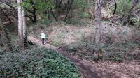
The trails vary from level flat paved surfaces to slightly more challenging packed dirt and rock paths which require a bit more attention to foot placement. None of the paths could be deemed to be difficult. There are 12 named trail segments within the park, many with a unique characteristic.

Old Fishermans Trail is a 0.3 mile segment that follows the southern edge of Lake Ralphine. Because it follows the shore it tends to be quite flat. Periodic side spurs lead from the trail to the lake shore where anglers look for the best fishing spots.

On the opposite shore, the Eagle Scout Trail also follows the lake's edge. But the character is different here. The trails tightly hugs the shore and thus provides better views of the lake. It's also has a rougher surface and requires careful footing at times.


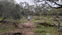
The Spur 6 Trail had rocky, lumpy features and rock piles that reminded us of quarry locations that we'd seen elsewhere.
The Sullivan Ridge Trail is one of the longest segments entirely within the park and follows the northern edge of the park property. It also follows the ridge that marks the high point of the property so a very modest little climb is required. The packed dirt surface is relatively smooth. Houses line the trail, which takes away a bit from the experience, but these eventually end once the trail reaches the boundary with the adjacent Spring Lake Regional Park. There are plenty of oaks with large boulders on either side of the trail, all covered in thick applications of moss.

The unexcitingly named trail Spur 6 turns out to be a bit more interesting than it's moniker. The rocky path twists through a field containing numerous small depressions, some filled with standing water. Piles of rough rock also speckle the landscape. The evidence seems to point to a quarry being in the area in the past.

After looping through a couple of trails the main parking area provides restrooms and even a food and drink convenience stand to refuel.

Photos
Moss
A portion of the Sullivan Ridge Trail passes beneath thick oak trees and between boulders, all covered with thick coats of moss. (Photo by Austin Explorer)
Falls
After Lake Ralphine water passes through the dam spillway it descends down this concrete waterfall and unceremoniously into a storm drain. (Photo by Austin Explorer)
Boat Launch
Lake Ralphine with the boat rental and launch center in the distance. (Photo by Austin Explorer)
Lake Ralphine
A boat glides across Lake Ralphine. (Photo by Austin Explorer)
Easy Path
A view along a stretch of a path sharing the name of no less than 3 trails on the official park map. (Photo by Austin Explorer)
Log Entries
A bit of everything
By Austin Explorer on 3/18/2018
Rating: 2stars Difficulty: 2stars Solitude: 2stars
Distance: 3.06 Miles Duration: 1 hour, 31 minutes

Coppertone and I were looking for something not too long or difficult today.  We had hiked at the adjacent Spring Lake Regional Park in the past but had never crossed the boundary into this park so we figured we'd give it a shot.

Howarth is one of those parks that seems to have something for everyone.  In addition to trails there are playfields, playscapes and even a miniature train.  The hiking is not a destination activity for those who live far away, but there is a surprising variety of terrain from completely flat paved surfaces to rocky hard packed dirt with a little bit of elevation gain.

You won't find a lot of solitude here, particularly on the easier trails near the center of activity in the park.  But as is typical, the farther away from a trailhead you venture the smaller the number of people you'll encounter.

The Spur 6 Trail had piles of rough rocks that resembled those we've seen in quarries elsewhere.  I need to do some research to see whether or not that was the case here.

When hiking down the Eagle Scout Trail on the north shore of Lake Ralphine we were able to see a young boy catch his first fish along the shore.  Unfortunately, the fish got loose right at the edge of the lake and got away, much to the young angler's disgust.  He threw his pole down and mother and and father were trying to encourage him and keep him motivated.

Recommended Item
Recommended Item Day Hikes Around Sonoma County: 125 Great Hikes
Robert Stone
List Price: $21.95 Your price: $18.52 Buy Now
Day Hikes Around Sonoma County is a collection of 125 of the county's best day hikes, providing access to both well-known and out-of-the-way greenspace. Hikes are found along the Pacific Ocean, across the coastal ridges, into wide valleys, and through thick forests. A third of the hikes are located along the coastline, accessed by Highway 1, which connects the coastal towns as it snakes along the oceanfront cliffs and bluffs. Many coastal access points that are not easily recognized from Highway 1 are clearly described. The remaining hikes explore the inland mountains, hillsides, and valleys through numerous state parks, regional parks, and undeveloped land. Highlights include fog-shrouded redwood forests, creekside canyons, wildlife sanctuaries, lakes, tidal bays, wave-pounded coastline, and sweeping panoramic views. A wide range of hikes accommodates amateur to avid hikers, from beachfront strolls to canyon treks. Straight-forward directions and clear maps accompany all hikes. A thorough index includes cities, trails, and points of interest.