Wilder Ranch State Park

Trail
34.00 Miles
N/A
N/A
4stars (4.00)1
2stars (2.00)
3stars (3.00)
N/A
Yes
N/A
N/A
Santa Cruz
Santa Cruz
More Info

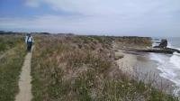
Ohlone Bluff Trail hugs the shore of the Pacific Ocean.
Since the arrival of European settlers, the land around Wilder Ranch served a number of owners for various agricultural purposes. More recently, it housed extensive dairy operations. By the late 1960's taxes on the property started to exceed the income from farming operations. Citizens of Santa Cruz County were able to fend off plans to develop the property for housing. California acquired the land in 1974.

Today the park's 7,000 acres stretch from near the top of Bald Mountain all the way to the Pacific coast. This provides a wide variety of terrain and vegetation. Douglas Firs and Redwoods dominate in the uphill areas leading down to Oaks, Manzanitas and grasslands. The widely varying habitat is reflected in the large variety of animals to be found here including deer, bobcats, coyotes and even mountain lions. Along the coast one can spot harbor seals as well as a number of birds that nest on the steep cliffs.

A view of the trail along the coast looking back towards the hill that contain yet more trails.
A cultural preserve area not far from the pay station leading into the park maintains a number of buildings and structures that highlight the ranch's previous history as a working dairy operation. Around this area and along the first mile or so of the Ohlone Bluff Trail you'll find most of the park's visitors. Continue walking past these areas for increased solitude.

The south east corner of the park is a natural preserve and access by humans is restricted. Be on the lookout for deer in the dense flats of brush. Because the beach here is off limits, a good number of shorebirds may be spotted resting on the sand.

Along most of the Ohlone Bluff Trail the landward side of the trail consists of agricultural fields still in active use within the park boundaries. Some of the fields contain organic operations and some that are less organic.

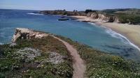
Trail overlook at three mile beach.
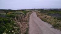
At a couple of spots along the trail creeks emptying into the ocean create dense thickets of shrubs leading the trail to turn inland in search of an easier passage. This turns out to be a path along the railroad that parallels the shoreline a bit further inland.

It may be easy to lose the trail at the railroad bypass upstream from Sand Plant Beach. The unpaved farm service road runs parallel to the much narrower trail at this point and one might be of the opinion that the trail is actually a rogue trail. Even if you get end up on the wrong fork here it will be fairly easy to cross back over as the official trail becomes more apparent.

When hiking along the coast, don't forget to look farther offshore. Whales travel up and down the coast at different times of year. The easiest way to spot them is by their telltale water spouts and they surface for a quick breath of air. They will typically swim beyond the kelp beds you can see offshore, but they will occasionally venture in even closer.

Photos
Captivated
Coppertone and I were captivated by the waves crashing into the rock at 3 mile beach. It provided some of the best splash we'd seen along the trail and it was so close. Here she's trying to capture some of the activity on camera. (Photo by Austin Explorer)
Saying goodbye
Coppertone soaks it all in before heading inland. (Photo by Austin Explorer)
Seagulls
We were buzzed by a flock of seagulls flying along the shore just feet away from the trail. Literally, a flock of seagulls. (Photo by Austin Explorer)
Pillar
This pillar looked far clearer once the Sun came out on our return back to the trailhead. (Photo by Austin Explorer)
Wildflowers
Much of the trail was bracketed by wildflowers. (Photo by Austin Explorer)
Shoreline
A view back along the shoreline with increasing Sun. (Photo by Austin Explorer)
Straight shot to sea
A view down to one of the beaches and out into the Pacific. (Photo by Austin Explorer)
Harbor Seals
A closer look at the Harbor Seals. (Photo by Austin Explorer)
Seals
On the dark peninsula to the left lay a good number of Harbor Seals at rest. (Photo by Austin Explorer)
Beach after beach after beach
Miniature beaches line the shore, separated by steep juts of rock. The steep faces of the rock provided nesting sites for many birds. (Photo by Austin Explorer)
Water meets rock
The trail provides many opportunities to watch the waves roll or crash into the shore. Here, a slight opening in the rock portends an eventual rock arch to come. (Photo by Austin Explorer)
Nature Preserve
A view from the overlook peering into the adjacent Wilder Beach Natural Preserve. A large number of birds on the sand seemed to be enjoying the solitude. (Photo by Austin Explorer)
Log Entries
Trails, wildlife and the ocean
By Austin Explorer on 5/13/2016
Rating: 4stars Difficulty: 2stars Solitude: 3stars
Distance: 7.95 Miles Duration: 5 hours, 52 minutes

Coppertone and I intended to do the entire Ohlone Bluff Trail today, but it turned out to be longer in reality than it looked like on the map.  We made it down to 3 mile beach, about three quarters of the way to end of the trail.  More to do later!

At a couple of locations the trail heads inland to avoid rough terrain along streambeds as they meet the ocean.  This means walking along the railroad tracks for a short distance.  For us, it meant balancing on the rails like a tightrope walker.

Near Sand Plant Beach we saw what looked like a dead sealion.  Its shape looked a bit different than the many Harbor Seals seen lounging on the rock shelves just above the water.

With a little bit of patience we were able to spot whales, perhaps Humpbacks, offshore.  Telltale water spouts and humped backs were paralleling the shore.  At least one was closer to shore inside the kelp beds.

As we prepared to turnaround we noticed someone intently checking out a bush nearby and taking notes.  Curiousity got the best of us and she turned out to be a botanist looking at the flowering plant that is normally found on the Channel Islands.  It was a bit of a mystery how it got here.

We doubled back to the trailhead, taking a slight shortcut at the railroad bypass and headed off to dinner.  There are a LOT more trails to try out here, most off of the ocean.

Recommended Item
Recommended Item Day Hiker's Guide to California's State Parks
John McKinney
List Price: $14.95 Your price: $12.00 Buy Now
Contains 150 day hikes in Southern California's magnificent state park system. Includes walks in the parks, preserves, and historic sites in mountains, forests, desert and coastal locales. From Anza-Borrego's palm oases (near San Diego) to the magnificent redwoods at Humboldt Redwoods State Park, Lake Tahoe's Emerald Bay to the Salton Sea. This single volume is a great addition to the library of every hiking enthusiast, families and seasoned veterans alike.