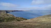
Point Reyes National Seashore

Trail
150.00 Miles
N/A
Free
3stars (3.00)6
2point5stars (2.83)
2point5stars (2.50)
N/A
Yes
N/A
N/A
Point Reyes Station
Marin
More Info
Drake's Bay
Drake's Bay

Point Reyes is a triangle of land tenuously joined to the rest of California by the famous San Andreas fault. Though part of Marin County, geologically speaking, this stretch of land has little in common with the rest of the county to the east. Point Reyes is part of the Pacific tectonic plate and originated in Mexico millions of years ago. The slow, but relentless work of the San Andreas Fault has ground Point Reyes along the coast of California to its present location.

Most visitors to Point Reyes probably get their start at the Bear Valley Visitor Station near one of the main entrances to the park. From here, there are several short trails that an introduction to the area's geological and historic features.

The actual earthquake induced gap is under the trees to the right. The light blue poles lined up mark the actual location of the San Andreas fault.

Several information kiosks along the Earthquake Trail highlight the active role played by tectonic plate movement in the shape of the California landscape. The most striking example is the reconstructed fence line that shows the 20 foot lateral movement of the Pacific plate with respect to the North American plate in 1906. The earthquake that caused this eery example of Earth's power also leveled much of San Francisco to the south.

The Kule Loklo Trail provides some insight into the lives of the Coast Miwok indians before the arrival of European settlers. There's a reconstructed village along the route. The structures include Kotcas, conical wooden structures that resemble teepees, as well as more substantial sweat lodges.

Cattle ranches started to sprout up here in the 1850's. At one point the dairy farms at Point Reyes were said to provide some of the best milk and cheese available in San Francisco. The cattle traditions of the area are alive and well today. A sizable percentage of Point Reyes remains under active management for cattle.

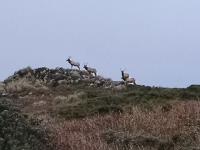
Tule Elk are plentiful along Tomales Point Trail

The Tomales Point Trail extends up a narrow peninsula to the northernmost point at Point Reyes. The trail is perhaps best known for having one of the largest concentrations of Tule Elk to be found anywhere. This subspecies of elk, found only in California, were nearly driven to extinction in the 19th century. Conservation efforts have restored them to around 4,000 individuals, many of which can be found here.

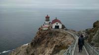
The Point Reyes Lighthouse and its support buildings.

The Tomales Point Trail is not terribly difficult, though it is one of the longer trails to be found in the park. Perhaps the most tiring aspect of the trail is the sandy surface for the last mile or so before reaching Tomales Point. Walking on sand can really tire one out.

The Point Reyes Lighthouse is widely known and this fact accounts for the large number of vehicles parked along the road leading to the start of the Point Reyes Lighthouse Trail. Numerous signs warn visitors about the 300+ steps that lead down to the lighthouse itself. Periodic rest platforms along the stairs allow those who need a breather to vacate the narrow stairs to allow others to pass.

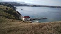
The Point Reyes Lifeboat station as seen from the Chimney Rock Trail

There are a couple of small trails that shoot out in numerous directions from the lighthouse parking area, or near it. The trail leading just to the north of the lighthouse provides good views of the ocean for whale watching at the right time of year as well as clear views of the expansive Point Reyes Beach that goes on for several miles to the north.

Not far from the lighthouse, on the opposite end of the Point Reyes Headlands, lies Chimney Rock. The Chimney Rock Trail does not have a picturesque lighthouse at the end to draw large crowds, so you're less likely to experience tourist gridlock here. To the north of the trail there are views of majestic Drake's Bay.

From the Chimney Rock trailhead, there's easy access to some historical structures that housed the Point Reyes lifeboat station. The restored lifeboat launch building once quickly slid 36-foot rescue boats down one of three rails into the water to assist the crews of ships that foundered on the treacherous rocks around Point Reyes.

Photos
Headed back
Coppertone takes in the views from the trail as we double back to the trailhead. (Photo by Austin Explorer)
Crowds
A sampling of the logjam of people descending to the falls as we were preparing to leave. (Photo by Austin Explorer)
Coppertone scales the slot
Coppertone works her way up the steep pitch off the beach from Alamere Falls. (Photo by Austin Explorer)
Beach
A shot of Alamere Falls with hikers resting on the beach below. (Photo by Austin Explorer)
Alamere Falls
A vertical shot of Alamere Falls. (Photo by Austin Explorer)
Lower Alamere Falls
The final step of Alamere Falls as it crashes onto the beach. (Photo by Austin Explorer)
Upper Alamere Falls
The top three steps of Alamere Falls before it falls onto the beach below. (Photo by Austin Explorer)
People
The first glimpse of the people around the top of the falls. The falls popularity would become even more apparent as we got closer. (Photo by Austin Explorer)
Towards the Falls
A view from the Alamare Falls Trail towards the Pacific Ocean. (Photo by Austin Explorer)
Pelican Lake
A little further down the trail, Pelican Lake's sole occupiers appeared to be waterfowl, including some of the lake's namesake. (Photo by Austin Explorer)
Bass Lake
Not too far off the trail, Bass Lake appeared to be a popular swimming destination. (Photo by Austin Explorer)
Trail View
Most of the Coastal Trail is a bit inland of the coast. Here one can spot hikers on the other side of valley heading uphill. There's even a bit of fog lingering. (Photo by Austin Explorer)

Only showing last 12 photos. View All Photos

Log Entries
Coastal Trail to Alamere Falls
By Austin Explorer on 7/24/2016
Rating: 4stars Difficulty: 4stars Solitude: 2stars
Distance: 9.77 Miles Duration: 4 hours, 43 minutes

Coppertone and I got what we thought was an early start for this trail, which we knew was popular.  We were lucky to secure the last parking spot in the Palomarin trailhead parking area just after 9:00 AM.  Later in the day when we were leaving there was a line of cars along the unpaved road for perhaps half a mile.

Alamere Falls is a well known landmark within the park.  However, it takes perhaps a bit over 4 miles to get to from the nearest trailhead.  Normally one would assume that means the crowds are kept at bay.  Not in this case.  The number of people on the trails heading to the falls was staggering.  It seemed rare that we would ever be out of site of someone else on the trail the entire length.  Amusingly, a good number appeared to be ill prepared for the mileage they were about to put in.

Despite the Coastal Trail's name, the Pacific Ocean doesn't come into view much.  The very steep terrain necessitates travelling inland to try and hug contours along the many small valleys that empty into the ocean.

We overshot the turn for Alamere Falls and did not realize this until we crossed Alamere Creek.  We doubled back a short distance and turned onto what at first appeared to be a rogue trail leading towards the ocean.  This turns out to be the way.

The side trail leading to the falls has different sections alternating between clautraphobic vegetation envelopement, open vistas to the ocean and steep, brittle slopes.  It was quite an adventure.  At the end we were rewarded by a stunning four step staircase waterfall that descends right onto the beach.

There were crowds of people at the falls.  The paths up and down the steep ravines to get to the falls and down to the beach were chocked with people, busy enough to require people to wait for long lines of people to clear out the path.  Thankfully, the crashing water at the bottom of the falls and the sound of the ocean were enough to drown out most chatter when we stopped to have a snack.

Tomales Point Trail
By Austin Explorer on 8/17/2014
Rating: 4stars Difficulty: 4stars Solitude: 3stars
Distance: 10.27 Miles Duration: 5 hours, 10 minutes

Coppertone and I saved our longest hike of the trip for the last day.  The trail starts off at the historic remains of the Pierce Point Ranch, which had raised cattle for dairy and meat from 1858 through 1973.

The trail surface is largely packed dirt, but turns sandy in spots.  Actually the last mile before the point is almost all sand and takes a lot out of already tired hikers.

The trail follows the ridge line, slightly west of the ridge's peak, on the Pacific side.  This means few, if any trees and lots of grass and shrubs.  Sunscreen is a must on sunny days.  We both got a bit of a burn from the failure to heed our own advice and it was rather overcast on our visit.

One of the draws for Tomales Point are the Tule Elk.  Nearly driven to extinction, their numbers are on the rebound and there's likely no better place on Earth to see them than here.  Any thought about being disappointed if we failed to see any were dashed both at the trailhead, where a few foraged on a distant hill and two miles into the hike, where a herd lay down to rest.  Actually we saw elk in numerous places along the trail, no more consistently than around the largest pond on the point.

When reaching the top of Tomales Point the trail snakes around some rock and into some gouges that have worn down some of the softer sedintary rock.  It was a nice place to sit and eat a snack and watch the ocean waves flow into Tomales Bay.

We were not alone at the turnaround point.  Spread out over 10 miles out and back, there were often times when one might be on the trail and not see anyone else in either direction.  But that did not last long.  For a trail of this length it's fairly popular.

Lighthouse Trail
By Austin Explorer on 8/16/2014
Rating: 3stars Difficulty: 3stars Solitude: 1star
Distance: 2.74 Miles Duration: 1 hour, 54 minutes

Everyone seems to come to Point Reyes for the lighthouse.  At least that's what we thought when we drove to the tip of the peninsula.  I think we might have walked as far from our car to the trailhead as we did from the trailhead to the lighthouse!

It's easy to see why it's the park's signature spot.  The lighthouse perched on the cliffs above the Pacific Ocean is stunning.  The 300+ steps (they are labeled) to get down from the cliff highpoint to the lighthouse is a deterent for some, but not many.

From the trailhead, the "trail" is actually a paved road, but it's closed off to all but official vehicles.

Just to the north of the Lighthouse Trail is a short trail leading to whale watching overlook.  Even if whales are not to be found (which they were not on our visit) the spot is ideal for views along Point Reyes Beach as it extends for miles to the north.

A couple of very short trails off the road lead to overlooks where one can catch a glimpse of sea lions resting on rocky ledges above the water.

Chimney Rock Trail
By Austin Explorer on 8/16/2014
Rating: 3stars Difficulty: 3stars Solitude: 4stars
Distance: 2.92 Miles Duration: 1 hour, 36 minutes

Coppertone and I drove a short distance from the crowds at the Lighthouse Trail and hiked to Chimney Rock towards the end of the day.  Perhaps it was the lack of a featured site or maybe it was also the apprach of dinner time, but we had much of the trail to ourselves.

The path is packed dirt and the terrain generally treeless.  Numerous deer were scattered about foraging on the grass.  To the left wide vistas of Drake's Bay could be seen.

Strangely, the park service marks unauthorized trails with the apt title "Unauthorized Trail".  It doesn't really say don't go on them.  They're just to let you know.  Coppertone and I refrained as we had enough miles to log on the established trails and didn't want to cause any degradation of the terrain.

The point on this side of the peninsula is not as picturesque as Lighthouse side, but we were able to enjoy the views without dodging crowds of people.

On the way back we passed by the historic Lifeboat station and support buildings.  Someone in the lifeboat building, which was closed for the day, was cooking their evening meal.  It smelled pretty good.

We wrapped up the day with a short jaunt from the trailhead to the Elephant Seal Overlook.  It was not the best time of year to look for them and only a few seals were on the beach, but they were there.  For a hike specializing in Elephant Seals I highly recommend Ano Nuevo State Park.

Kule Loklo and Morgan Trails
By Austin Explorer on 8/15/2014
Rating: 2stars Difficulty: 2stars Solitude: 3stars
Distance: 2.38 Miles Duration: 1 hour, 19 minutes

Penny and I started off our Point Reyes trip with a couple of easy hikes around the main visitor station of the park.  Kule Loklo features a recreated Coast Miwok village as it might have looked 200 years ago.  The shelters are interesting, but we were disappointed that the largest structure in the village was locked up.  The gaps in the door provided evidence that the temperature inside was a good deal cooler than that outside.

Doubling back from the village may be the easy way out.  We made a loop out of it by jumping on the Horse Trail and then Morgan Trails.  Neither transition to these trails was very clear, making it a tough sell for the casual visitor.

As you might expect, the Horse Trail is shared with equestrian riders, as is the Morgan Trail.  So expect to encounter horses there and yield as the pass.

This trail is not ADA compliant, but it's fairly short and flat so it's easy enough for almost all abilities.

Earthquake Trail
By Austin Explorer on 8/15/2014
Rating: 2stars Difficulty: 1star Solitude: 2stars
Distance: 0.79 Mile Duration: 37 minutes

Point Reyes lies at the boundary between the North American and Pacific plates, so of course we had to hike the interpretive trail that details the area's geologic history.

The trail itself is ADA compliant, paved and mostly flat.

It's suitable for all ages.  Actually, even the interpretive signs are tailored for all ages.  Every display comes in an adult and kid version, each customized for different levels of understanding.

The highlight of the trail is the earthquake fence.  The 1906 earthquake that leveled large parts of San Francisco left a startling bit of evidence here as well.  A fence line that had been a continuous straight line was cut in two with both halves separating by 16 feet.  Portions of the fence was left to illustrate the radical changes in terrain that can occur when earthquakes occur.

Recommended Item
Recommended Item 101 Hikes in Northern California: Exploring Mountains, Valley, and Seashore
Matt Heid
List Price: $17.95 Your price: $4.99 Buy Now
101 Hikes in Northern California encompasses the full spectrum of the region’s incredible natural diversity—the jagged granite of the High Sierra, crashing surf of the Pacific Coast, magnificent redwoods of the North Coast, spectacular views of the Bay Area, and much more. All trips have been thoroughly updated for the second edition, and 26 trips have been significantly expanded or reworked. Each hike description includes an easy-to-use header outlining the trip basics, driving directions, an in-depth trail description, up-to-date map, and the locations of the nearest visitor center and campground.