St. Edwards Park - Hill Trail

Trail
2.00 Miles
300 Feet
Free
3point5stars (3.60)35
2point5stars (2.82)
3point5stars (3.56)
N/A
Yes
Yes
No
Austin
Travis
More Info

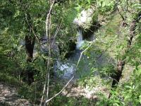
Although the trail parallels Bull Creek for some distance, the dense foliage provides just a few glimpse of the water below, such as this one of the dam.
Getting there: The trailhead resides on the north side of Bull Creek between the creek and Spicewood Springs Road. From Hwy 360, take Spicewood Springs west for about two miles. Be on the lookout on the left for a small parking area to the left with a white mailbox. At this spot there is parking for at most 4-5 cars parked parallel to the road.

The Hike: The other side of Bull Creek provides a whole different St. Edwards Park than that which hugs Spicewood Springs Road upstream. The terrain here is hillier and more challenging and one never need breath in any auto exhaust fumes at any point along the trail.

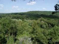
The trail leading up to the Overlook waypoint provides numerous grand views of the other side of St. Edwards Park below.
The trail begins at the waypoint "Trailhead" and heads down a gentle slope to Bull Creek. At the creek strategically placed rocks allow for hikers to cross the creek without having to get wet. During wetter periods wading is an option. A more dangerous, but drier option is to follow Spicewood Springs Road towards the east a short distance until it crosses the creek and then turns onto the trail that starts there. This is not recommended for anyone with children however. There is NO shoulder on the road or sidewalk and one must be constantly aware of any oncoming traffic and be prepared to jump into the road-side brush at any moment.

The Hill Trail includes some steep ascents, but nothing that should require using your hands for support.
A city park sign on the opposite side of the creek enlightens visitors that this section of St. Edwards Park operates under slightly different rules than the rest. Since it operates as part of the Balcones Canyonlands Conservation Program dogs must be on leashes here.

The trail gains elevation as it parallels the creek. Eventually the hiker is rewarded with great views, though with dense foliage partially screening the scene, of the small dam on the creek. The trail surface becomes more rocky as it continues to rise of the creek. The farther west the trail goes the higher and more impressive the vistas. At the waypoint "Overlook" there is one final view over the lowland portion of the park on the opposite bank before the trail turns away from the creek and starts to climb more directly uphill.

Upon climbing about 50 feet the trail levels off somewhat as it hugs slope of a stream canyon. We continued in this circular, clockwise pattern until we got to the waypoint "T-Right". The trail meets up with a wider trail that presents two options. One option is to turn to the left and head back towards the trailhead and call it a day. If you haven't liked the climbing so far then turning left may be the best option for you.

Dense thickets of Cedar provide shade along the trail farther uphill.
By turning right we committed ourselves to more climbing. The trail becomes wider and more rocky at this point in the hike. Eventually high tension power lines will loom overhead. Under the towers the trail sets a perfectly straight path right up the hill.

The trail near the apex of the park is wider than elsewhere and straight as an arrow, just like the high-tension power lines overhead.
We made a small loop of the trails near the top of St. Edwards Park, marked by the waypoint "Preserve". St. Edwards Park on this side of the creek is shaped like a triangle with this point at its apex. Chain link fences mark the boundary between this park and the preserve land on the opposite side. At this corner there is an entrance into the preserve with signs noting the ground rules. There are miles of trails to explore on the other side of the fence if you have the time.

We turned around at this point and took the power line jeep trail straight down the hill, partially retracing our footsteps to the trailhead. The trails on this side of St. Edwards Park are numerous, which provides for a multitude of hiking options beyond what we did during our trip. If you like to climb some moderate slopes and want to get away from the traffic along Spicewood Springs then the south side of St. Edwards Park is for you!

Photos
Typical plant community - LOTS of juniper
Nice shade, lovely spicy scent, not a ton of variety. (Photo by plectrudis)
Carolina Buckthorn on Edge of Bluff
A Carolina buckthorn in fruit on the edge of the bluff. (Photo by plectrudis)
Pretty, autumnal blue skies
Sky was mellowly autumnal, but it was super-humid and sticky. Still, the views were gorgeous. (Photo by plectrudis)
Lovely view from on top of the hill
Lovely view from on top of the hill (Photo by plectrudis)
coming down off the hill
coming down the trail towards the creek (Photo by jimmy peace)
on the back side
on the back side (Photo by jimmy peace)
peeling bark
peeling bark (Photo by jimmy peace)
the dam on the creek
the dam on the creek from the hillside (Photo by jimmy peace)
on hill side
on hill looking down (Photo by jimmy peace)
More rules for the preserve
more rules for the preserve (Photo by kmcippant)
Rules to go in the preserve
rules to go in the preserve at the top of the hill (Photo by kmcippant)
St. Edwards Park Map
There's a number of trails and then some more information about the park. (Photo by kmcippant)
Log Entries
Beautiful views, some steepish bits
By plectrudis on 10/2/2017
Rating: 3point5stars Difficulty: 3point5stars Solitude: 4stars
Distance: 3.75 Miles Duration: N/A

Parked at the main lot and hiked east to the dam (crossed on the rocks below the dam).  Stumbled around a bit trying to find the real trail on the far side--would have been easier if I had crossed by the eastern mini-parking lot.

Some of the hilltop views from this trail are really beautiful, and the copious cedars mean that the hike has a lovely, spicy smell.

I didn't have time to go into the golden-cheeked warbler preserve, unfortunately, but it was nevertheless quite a nice hike.  There are some inclines that are a bit aggressive, which is either a good thing or an annoying thing, depending on your preferences, but in between there were plenty of mostly level bits.

Botanizing was a mixed bag--SO MANY junipers and silktassels, over and over--but I did spot a pretty little native orchid and a gnarly old escarpment black cherry, so that was nifty.

i hadnt hit the top trail before, nice trail, few people
By jimmy peace on 3/28/2016
Rating: 3stars Difficulty: 3stars Solitude: 3stars
Distance: 2.50 Miles Duration: N/A
By texaskdog on 3/10/2015
Rating: 4stars Difficulty: 3stars Solitude: 4stars
Distance: 2.00 Miles Duration: 50 minutes

It was wet today but water here is easy to navigate, as long as you cross the overflowing creek on the road.

great hike
By jimmy peace on 7/13/2014
Rating: 3point5stars Difficulty: 3point5stars Solitude: 4stars
Distance: 1.60 Miles Duration: N/A

i had never hiked this part, actually more work then the normal trail since all up and down, not level 

Love this park
By Sunshinedog on 7/9/2014
Rating: 3point5stars Difficulty: 3point5stars Solitude: 4stars
Distance: 8.00 Miles Duration: N/A

We (me and the dog, of course) hiked the entire trail, including cross over the road and hiking up the other side.  This hike can be challenging in spots coming down from Balcones Reserve it is very steep and you need to "climb" down.  Park in the parking lot to secure your vehicle.

By Jamie on 1/1/2014
Rating: 4point5stars Difficulty: 3point5stars Solitude: 3point5stars
Distance: 2.00 Miles Duration: N/A
By ValEpiscopo on 8/5/2013
Rating: 3point5stars Difficulty: 4stars Solitude: 3stars
Distance: 2.50 Miles Duration: 1 hour, 15 minutes

Walked the loop gping right.

Our first "epic" hike, according to my 12 year old
By terlanmat68 on 9/15/2012
Rating: 2point5stars Difficulty: 2stars Solitude: 3stars
Distance: 1.63 Miles Duration: 45 minutes
We had lots of fun crossing Bull Creek and then climbing the trail up to the south. My son was excited by the quick elevation gain up to tree top level. We followed the creek around until we encountered a barb wire fence. Went back downhill along the fence, crossed back over the creek and followed a creek-bed trail back to our previous crossing. Made for a quick mile and a half loop. BTW, we parked at the larger, more northern, parking lot. There is a quick, easy connection trail to get down to the creek.
nice!
By actualattic on 4/4/2012
Rating: 2stars Difficulty: 2point5stars Solitude: 3point5stars
Distance: 1.50 Miles Duration: N/A

After doing the creek trail this one pooped us out. The rocky trail kept us slow, but we made it to just about the top of the hill before turning back. Only saw one person on this trail. Will return again to finish soon.

Great Hike - Nice Views
By Ernie Herrera on 10/15/2011
Rating: 3point5stars Difficulty: 2stars Solitude: 2point5stars
Distance: 3.00 Miles Duration: N/A
Hiked the hill side of the trail at St. Edwards Park after parking along the roadside on Spicewood at the 5th low-water crossing. This was our first time at the park and I was accompanied by another friend and our 3 daughters ages 4, 7 and 11. We walked along the creek and saw crossed at the dam to the other side of the creek. We followed the trail and it led us around and up the cliff side of the creek. The views were very nice and the kids were all able to handle the ascent. We continued along the trail until we reached the fenceline on the south side of the park and headed towards the preserve. The descent started as we turned left at the preserve entrance. We saw one warbler and lots of vegetation and found some fossilized sea shells along the way. We all enjoyed it and will be back for sure.

Only showing last 10 log entries. View All Log Entries

Recommended Item
Recommended Item 60 Hikes Within 60 Miles: San Antonio and Austin: Including the Hill Country
Charlie Llewellin, Johnny Molloy
List Price: $18.95 Your price: $15.91 Buy Now
It's Time to Take a Hike in San Antonio!

The San Antonio and Austin areas are steeped in history -- San Antonio's Alamo stands as a symbol of Texas' fierce independence, while Austin is recognized as the cradle of Texas statehood. This area is also known for some of the most impressive hiking in the Lone Star State. 60 Hikes Within 60 Miles: San Antonio and Austin, by veteran authors Charlie Llewellin and Johnny Molloy, guides readers to the best trails found in the Texas Hill Country, all within easy reach of these two cities. The guide takes you to secluded, low traffic areas as well as those that are more popular and heavily used. The former LBJ Ranch, the Guadalupe River, the Highland Lakes Chain, and the Lost Pines area are just some of the spectacular places covered.

With this new edition in the best-selling 60 Hikes Within 60 Miles series, all these visually stunning and ruggedly charming routes are at the traveler's fingertips. This handy guide helps San Antonio and Austin natives get back into nature, with many options right in town. Extensive at-a-glance information makes it easy to choose the perfect hike based on length, difficulty, scenery, or on a specific factor such as hikes good for families, runners, or birding. Each trail profile includes maps, directions, driving times, nearby attractions, and other pertinent details.