Getting there: The Mayfield Nature Preserve sits next to the Laguna Gloria
Museum in Tarrytown. To get there, take the 35th street exit off of MoPac and head
west. After passing Balcones Drive prepare to veer to the left at a Y in the road. At this
point 35th Street turns into Old Bull Creek Road. Look closely for an entrance to the
nature preserve on the left soon after the Y.
The Hike: This hike starts off next to the large trail map sign near
the preserve parking lot. The waypoint "Trailhead" indicates the location. As we walk
down the trail that Mayfield refers to as the Lake Trail Loop the stone fenced garden
resides to the left. Our travels will end up on the opposite side of the garden towards
the end of the hike.
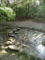
All of the creek crossings at Mayfield are easy. However, this one is particularly interesting.
The trails at Mayfield consist of shredded wood chips at the start of the trail. Eventually
the trail consists of packed dirt and is well maintained. Although some portions of the
trail can be steep these sections are usually maintained as staircases, making them fairly
easy to navigate even for beginning hikers.
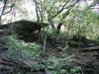
This hike gets its name from the interesting rock ridge we encountered.
The trail heads toward to the inlet that feeds into Lake Austin. In our first loop of the
day we saved the lake hike for later. Instead we turn to the left onto
Mayfield's Creek Trail and head towards the eastern edge of the preserve. After
crossing the creek continue to head east and you'll soon come up to a rock ridge with
some small, but impressive rock overhangs. This spot is marked by the waypoint "Rock Face".
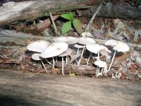
Arrive early enough at Mayfield Park and you may see some plantlife that enjoys the areas shadows.
Upon exploring the top of the rock face we noticed a small, unofficial trail that continued to
the south along the ridge. The clearance here is minimal and occassionally the trail
hugs right along the edge of the small cliff that overlooks the stream valley below. It is
not a recommended side trip if you are sensitive to heights or unsure of your footing.
-small.jpg)
Much of Mayfield is heavily wooded, but the Sun manages to peak through here and there.
The waypoint "Turnback" is the point at which we ran into a fence that marked the boundary
of the preserve. Through the clearing we could see houses not too far off, so this is
really the extent to which you want to proceed. We turned back to the start of our side
trip and then continued north.
-small.jpg)
Steeper sections of the trail have been made into staircases, so getting around is not a problem.
When the trail approaches the waypoint "Mayfield Cache" you pass into a wide creek valley.
The trail passes right next to the Mayfield geocache that you can hunt for if you're
interested. To the left sits a large rock face, at the top of which sits the
Mayfield house and garden's stone wall. A short distance to the north, stair steps lead
the trail to the top of the ridge. Once on top of the ridge a gate provides entrance to
the fenced in area of the Mayfield house. Here you'll find ponds with fish and roaming
peacocks.
By passing through the gardens you'll be able to get back to the parking area and the
trailhead. We recommend that you spend a few moments here to admire the beauty and
serenity of the surroundings. The hike described here is not very long, only being
about half a mile but the beauty of the area is compelling in and of itself.