-small.jpg)
The Warren Skaaren Environmental Learning Center contains a number of interpretive displays and a solar calendar built into the roof. Tours start here.
From Austin head west on Hwy 71. Turn left onto RR 3238 (Hamilton Pool Road). Head south for a bit over 14 miles to the Pedernales River. The entrance to Westcave Preserve is the first gate on the right after crossing the river.
The Hike: Westcave Preserve is a small piece of land owned by the Lower
Colorado River Authority. What it lacks in acreage it makes up in scenery. This little brother to nearby Hamilton Pool offers some of the same formations, and some unique ones, and does so with far fewer crowds.
-small.jpg)
An observation deck provides a view over the Pedernales River valley below. The river can just about be seen between the trees.
The trail begins at the waypoint marked "Trailhead", which resides at the Warren Skaaren
Environmental Learning Center. Access to the trails at Westcave are by guided tour only. On weekends tours start at 10:00 AM, Noon, 2:00 PM and 4:00 PM. A $5 per person fee helps cover the expenses of maintaining the property.
The trail starts off flat as it heads north along the bluff overlooking the Pedernales River. The waypoint "Overlook" marks the spot of a wooden deck that provides a view of the Pedernales below. Be sure to ask the guide for a description of how high the water can get on the Pedernales in a big flood. You'll be amazed.
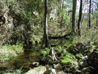
The cool, wet conditions at the bottom of the canyon play host to plant life that resemble something you'd see in Jurassic Park.
The trail descends into the canyon and things change dramatically. The trail gets rougher and steeper, so much so that steps have been put into place and steel cable handholds installed. The safety features are more intended for the non-hiker visitors, but it still indicates a big change in difficulty.
Whereas the foliage at the top of the canyon resembles what most people think of when they picture the Hillcountry (Oaks, Junipers, grasslands) the vegetation in the canyon itself is far different. At times it more closely resembles what one might picture when thinking about Jurassic Park. Large Cypress trees stretch their meandering roots along the water's edge. Ferns dot the landscape. The air is appreciably cooler and wetter, just a hundred yards away from the hillcountry above.
-small.jpg)
The grotto at the end of the canyon. Water here cascades over the rim, mostly to the right of the picture, behind the tree. Note the abundance of ferns along the grotto rim.
The trail parallels the creek towards the west until it comes to the grotto that made this
patch of land important enough for the LCRA to purchase it. Layers of rock have collapsed, leaving an overhang of rock over which water falls into the small pool below. Ferns cling to the rim high overhead and dripping water forms flowstone on the rock below. A cave to the right of the grotto features stalactites and on my visit even a couple of bats.
The cave provides the opportunity to see stalactite formation in process. The conditions here provide for relatively fast growth and the unique addition of algae in the process can contribute to formations that actually lean towards the Sun.
The return trip retraces our steps back to the Environmental Center. Most of the elevation gain is encountered on this second leg. In total the round trip covered about three quarters of a mile. Though short, the interesting and challenging terrain and the guided tour make it not only an enjoyable hiking experience, but also an educational one.