West County Regional Trail

Trail
5.57 Miles
N/A
Free
2stars (2.00)2
1star (1.00)
1star (1.00)
N/A
Yes
Yes
N/A
Sebastopol
Sonoma
More Info

History

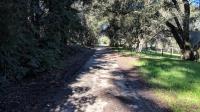
The trail in Sebastopol goes through neighborhoods and is usually shaded.
Much of the path for the West County Trail was once the route of the Petaluma & Santa Rosa Railroad (P&SR). Construction between Sebastopol and Petaluma started in 1904. The railroad used electricity to power its engines and the cars resembled street cars. When the line was expanded in 1905 the line needed to cross an existing line of the California Northwestern Railroad (CNW). When a legal block to prevent P&SR from inserting a crossover failed P&SR was physically prevented from accomplishing the task by CNW workers. Competing crews from both railroads broke out into an open fight that drew a crowd of several hundred resident spectators. The melee came to be known as the The Battle of Sebastopol Road. Eventually, the crossover was put into place.

Though CNW could not stop the P&SR, economics and a changing economy did. Passenger service was discontinued in 1932, the same year the railroad was taken over by Southern Pacific. Even freight service declined. Over time segments of the line were abandoned, with the last bit being left behind in 1984. In that same year, the Regional Parks Department starting to acquire parts of the railroad right-of-way for use as a trail. Additional private and public entities providing assistance and funds over time to expand the trail to its current length between Sebastopol and Forestville.

The Trail

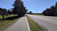
The trail along Highway 116 is little more than a sidewalk, but does provide wider views of the surrounding vineyards and orchards.
At the southern end in Sebastopol the trail starts at North Main Street. There is a "connection" with the Joe Rodata Trail to the southeast but it partly relies on walking along roads. The connection seems tenuous.

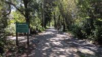
There's ample street parking near the trailhead. A nice sign provides a map of the trail and on the back a history of the rail line that used to exist here.

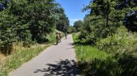
The West County Regional Trail is popular with hikers and cyclists alike.
The path is mostly paved and flat and thus suitable for walkers and cyclists of all abilities. It should also be ADA compliant. Signage seems to indicate that horses are allowed on the trail. Given the paved surface one seems unlikely to see much equine use. The path is quite popular with cyclists.

At the southern start of the trail you may see names painted on the trail surface from time to time. These are names of the streets being crossed or cul-de-sacs abutting the trail. It's a handy way to orient yourself along the trail and certainly a cheaper option to inform trail users than erecting signs.

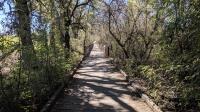
Bridges and boardwalks ensure trail users can make their way.
In Sebastopol the trail cuts through neighborhoods with trees providing ample shade. Once the trail makes it to Highway 116 its nature changes. It becomes little more than a sidewalk to the often busy road.

Between Sebastopol and Graton along Highway 116 lies Andy's Market. The produce market does a brisk business and it's refreshing how welcoming the establishment is to the trail. A path leads from the trail to the front of the store with signage that seems enticing to walkers and cyclists. There's a nice spot to sit outside and enjoy some coffee, food or drinks purchased here before continuing on your way.

The trail gets its northern start in the town of Forestville.
For various reasons, the entirety of the original rail line could not be turned into a contiguous trail. Disjointed segments have to jog around private property at a couple of roads along the trail's route. The longest segment of this is about 3/4 of a mile along Occidental Road near Graton. Smaller 1/4 mile segments along Ross Road in Graton and Green Valley Road north of it slightly mar the experience, but not too much.

Though mostly paved, there are some sections of trail here and there that are comprised of either hard pack dirt or even boardwalk. Just south of Forestville at Green Valley Road, near a water treatment plant, there are segments of both of these trail surface types.

The trails comes to an abrupt halt in Forestville in the north. There's even a sign that explicitly states it to be "end of trail". Officially the trail dumps out here onto Pajaro Lane to the right. But the parking there is less than ideal. But going past the end of trail sign a more overgrown path continues for about a quarter mile further to Front Street (a.k.a. Highway 116). This takes you to the heart of Forestville and there is ample parking here if you'd like to start you hike from this side.

When the temperature is pleasant and the Sun comes out, so do the people. Don't expect a lot of solitude here on the trail closer into the towns when the weather is nice.

Photos
Sonoma County Eggs
A farmhouse right off the trail was selling fresh eggs using the honor system. (Photo by Austin Explorer)
Creek Crossing
Bridges make light work of a couple of creek crossings we encountered. (Photo by Austin Explorer)
No More Pavement
As the trail nears Green Valley Road the pavement ends, though the trail is still quite easy to traverse. (Photo by Austin Explorer)
End of the line
The end, or start, of the trail is here. The more overgrown path that continues leads to ample parking on Front Street in Forestville. (Photo by Austin Explorer)
Shamu
An unexpected attraction along the trail. (Photo by Austin Explorer)
Log Entries
First hike as part of the Sonoma County Trails Challenge
By Austin Explorer on 6/8/2019
Rating: 2stars Difficulty: 1star Solitude: 1star
Distance: 5.01 Miles Duration: 1 hour, 59 minutes

Coppertone and I logged our first hike as part of the 2019 Sonoma County Trails Challenge.  Since she was still coming off of an illness and not quite up to 100% recovery we decided to chose an easy one to start off with.

We'd already done the southern half of this trail earlier this year, so it was a relief that the challenge recommended the northern half so we would not have to redo a trail we had visited not that long ago.

We started off in the parking lot on Front Street (Highway 116) and headed south.  Technically, this is not part of the regional trail, but it meets up with it in about a quarter mile and there is much more parking here.  At the official start of the trail off of Pajaro Lane there is only street parking and not much of it.

Being a rail trail, the West County Trail is mostly flat and easy going.  From the start the path is mostly paved.  About 2 miles down the road the path changed into something like gravel.  It was still easy to traverse.  Right near Green Valley Road before we turned around the path turns into a raised wooden walkway over a boggy area near the Gratan water treatment plant.

Bicyclists outnumbered walkers on this day due in part to a fund raising century ride (100 miles).  The cyclists were sporadic and well spread out throughout our walk, so the trail must have been closer to the end of their route.

The days are getting hotter and the ample tree cover in here and there was a welcome relief from the Sun.  Where the trees did not dominate the terrain it seemed blackberries did.  Large mounds of blackberry bushes dotted the landscape, in some cases just starting to reach out into the path of the trail.  Later this year there should be ample berries for picking up a mid-hike snack.

Vineyards dot the landscape throughout the hike.  We spotted a couple of California Quail scurrying in through the high grass just on the edge of a one of them.  A cute farmhouse right off the trail was selling fresh eggs on the honor system.  Small producer Ektimo Wines has a small sign pointing to their tasting room a very short distance off the trail near the trail crossing of Ross Lane.

Easy Stroll, Killer Whale ... and grocery shopping
By Austin Explorer on 2/18/2019
Rating: 2stars Difficulty: 1star Solitude: 1star
Distance: 4.70 Miles Duration: 1 hour, 57 minutes

Coppertone and I were eager to get a bit of mileage in and start building up our legs for more serious hiking when the weather turns nicer.  After so much rain, the fact that the trail surface here was paved meant we didn't need to worry about getting mired in the muck.

This is mostly an old rail line, so the path is made up of large straight segments with little elevation gain.  The first segment was heavily covered by trees and neighborhoods crowded in from both sides.  We unexpectedly came across a Killer Whale adjacent to the trail.  The fiberglass or plastic Orca head was a surprise to us.  A child passing by with his mother obviously knew about it as he anxiously waited for it to come into view.

Once the trail ran into Highway 116 it became more of a sidewalk.  Though the traffic here is a negative, there were now more open views into the orchards and other agricultural fields that started to dot the landscape.

Along the way we encountered Andy's Market, an open air produce supplier with a large grocery selection as well.  We're both gluten free and their selection here of those items was excellent.  We ended up stopping for lunch on the way back and then driving back after our walk to purchase groceries before heading home.

We turned around when the trail ran into Occidental Road.  At this point the trail would have followed the road for over a half mile before turning into more of a proper trail.

Recommended Item
Recommended Item Day Hikes Around Sonoma County: 125 Great Hikes
Robert Stone
List Price: $21.95 Your price: $18.58 Buy Now
Day Hikes Around Sonoma County is a collection of 125 of the county's best day hikes, providing access to both well-known and out-of-the-way greenspace. Hikes are found along the Pacific Ocean, across the coastal ridges, into wide valleys, and through thick forests. A third of the hikes are located along the coastline, accessed by Highway 1, which connects the coastal towns as it snakes along the oceanfront cliffs and bluffs. Many coastal access points that are not easily recognized from Highway 1 are clearly described. The remaining hikes explore the inland mountains, hillsides, and valleys through numerous state parks, regional parks, and undeveloped land. Highlights include fog-shrouded redwood forests, creekside canyons, wildlife sanctuaries, lakes, tidal bays, wave-pounded coastline, and sweeping panoramic views. A wide range of hikes accommodates amateur to avid hikers, from beachfront strolls to canyon treks. Straight-forward directions and clear maps accompany all hikes. A thorough index includes cities, trails, and points of interest.